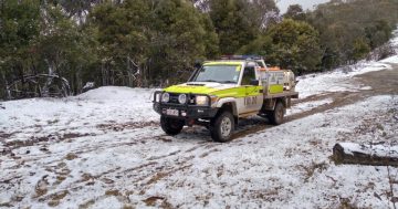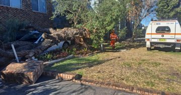
Damaging winds are forecast for elevated areas today (26 May), broadening along the Great Dividing Range and Illawarra on Tuesday (27 May). Photo: BoM.
A powerful cold front is making its way across the country with strong winds both heralding its coming and expected in its wake.
The leading edge of the front made its presence known at higher elevations overnight, with Mount Thredbo recording 102 km/h winds.
Bureau of Meteorology senior meteorologist Dean Narromine said overnight wind gusts were a sign of things to come as the main section of the “strong and powerful” cold front moved east.
“A wild and woolly day [is] expected for much of southern and southeastern Australia,” he said.
“[The cold front] is likely to bring widespread showers, local hail and thunder, and we could even see snow developing through our alpine areas later tonight.
“We’re also likely to see widespread damaging winds, abnormally high tides … we could also see widespread areas of raised dust because it’s so dry.”
A rainband is developing over inland NSW, which will also move eastwards throughout the afternoon and night.
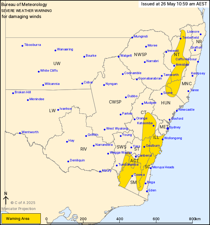
The strength of the winds depends on elevation, with alpine areas above 1900 metres expected to experience peak gusts around 125 km/h.
Damaging winds averaged 60 to 70 km/h, with peak gusts around 100 km/h, are expected for the Snowies and ACT ranges above 1400 metres.
Blizzard conditions are also possible over parts of the Snowy Mountains district above 1400 metres from late tonight.
The NSW National Parks and Wildlife Service has recommended that country travel be postponed until conditions improve.
Mr Narromine said Tuesday (27 May) would deliver much of the same as the system tracked eastward.
“We’re likely to see a burst of very strong winds across eastern NSW on Tuesday morning, for coastal areas and our flood-affected areas as well,” he said.
For remaining southeastern NSW areas, including Wollongong, damaging winds averaging 55 to 65 km/h, with peak gusts in excess of 90km/h, are expected to develop Tuesday morning.
Locations which may be affected include Wollongong, Nowra, Bowral, Braidwood, Goulburn, Selwyn, Bredbo, Adaminaby and Nimmitabel.
The State Emergency Service advises that people should:
- Move vehicles under cover or away from trees
- Secure or put away loose items around your house, yard and balcony
- Keep at least 8 metres away from fallen power lines or objects that may be energised, such as fences
- Trees that have been damaged by fire are likely to be more unstable and more likely to fall
- Report fallen power lines to either Ausgrid (131 388), Endeavour Energy (131 003), Essential Energy (132 080) or Evoenergy (131 093) as shown on your power bill
- Stay vigilant and monitor conditions. Note that the landscape may have changed following bushfires.
For emergency help in floods and storms, ring your local SES Unit on 132 500.
Original Article published by Claire Fenwicke on Region Canberra.
Original Article published by Claire Fenwicke on About Regional.