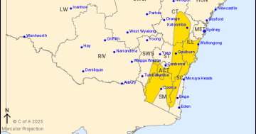
Forecast wind gusts for 5 pm on Friday, 27 March. Photo: Weatherzone.
Damaging winds, heavy rain and large waves are all on south-eastern NSW’s dance card from Friday (27 March) onwards as a powerful low-pressure system crosses the region.
The colder air mass is sweeping over Victoria and Tasmania today (26 March), lowering Tasmania’s snow level to about 1000 metres and bringing lots of rain.
That moisture will then be sucked into NSW, with the chance of severe thunderstorms over parts of Canberra and the Southern Tablelands late this afternoon and into the evening. There’s also a risk of damaging winds and hail.
A low-pressure system is also expected to develop off Victoria’s east coast before moving north.
“That low-pressure system could drive damaging winds right through south-eastern parts of NSW early Friday, into Saturday as well,” Bureau of Meteorology meteorologist Jenny Sturrock said.
“Rainfall totals [for southeast NSW] across the three days [to Sunday] could be in excess of 50 to 100 mm.”
It’s the coastal low-pressure system centred off the South Coast that’s expected to be the most dangerous part of the upcoming weather event.
Weatherzone meteorologist Ben Domensino said southerly winds would strengthen “considerably” over eastern areas of NSW and the ACT.
“In addition to the wind, heavy rain and highland snow will affect eastern Victoria and southeast NSW on Friday,” he said.
“The coasts in eastern Victoria and NSW will also get hit by huge waves on Friday and Saturday, with wave heights expected to reach around 3 to 5 metres, possibly exceeding 5 metres along the NSW coast late Friday into Saturday morning.
“These waves will make coastal activities, including swimming and fishing, dangerous, and they will cause coastal erosion at south-facing beaches.”
The burst of wintry weather will be especially noticeable given the recent warm spell across the regions.
Canberra’s forecast to reach a maximum of 15 degrees on Friday, following a week-long run of temperatures above 26 degrees over the past seven days.
Bega’s looking at a top of 16 degrees and up to 45 mm of rain on Friday, and Moruya is facing a similar forecast.
Damaging winds are possible for Wollongong, along with up to 30 mm of rain and a top of 18 degrees.
The difference is stark as you look further inland, with a low chance of at least 10 mm falling over Wagga Wagga.
But locals there will still feel the chill with a top of 19 degrees forecast following a run of maximum temperatures in the high 20s to low 30s.
And none of that takes into account the wind chill from the forecast snow for the mountains.
The Bureau of Meteorology will issue severe weather warnings as these systems form and move through the regions.
A hazardous surf warning has already been issued for the Illawarra, Batemans and Eden Coasts for today and tomorrow.
NSW Police Force Marine Area Command has advised:
- People should consider staying out of the water and avoid walking near surf-exposed areas
- Rock fishers should avoid coastal rock platforms exposed to the ocean and seek a safe location that is sheltered from the surf
- Boaters planning to cross shallow water and ocean bars should consider changing or delaying their voyage
- Boaters already on the water should carry the appropriate safety equipment and wear a lifejacket
- Boaters should remember to log on with their local Marine Rescue radio base, via VHF Radio or the Marine Rescue APP, and consider their safety management plan.
Original Article published by Claire Fenwicke on Region Canberra.